remote images |
Remote Images
![]()
The new dimensions of the global world demand a new cartography: of the dynamic, the fluxes, the permanent and variable reconfigurations. The aerial perspectives had redefined the visual culture, with its ambition to a universal rhetoric, but they kept a proximity to the maps: they obeyed to the legible space determinations. Non-visual space-time, in contrast, evidences the limits of the conventional mapping.
Some conventions, proper to the visualizations of geographic information, of mapping, persist in the remote sensing. This is what allows, sometimes, that these encompassing images to convert perception into spectacle. But production and interpretation of images by remote sensing imply other procedures. They codify information on energy standards, changeable over space and time, of which the object existence only can be deduced. Impossible to infer its presence. Representation problem: they send to non-visible phenomena.
The remote sensing by satellite has provided a global perception, but the form accomplished by this perception is determined by specific objectives, in accordance with efficiency criteria established by the corporations that control the databases, the programs and the access to satellite services. The perception fragmentation in momentary and disconnected sets transformed it into management instrument. The advanced logic of contemporary mapping seems to constitute an apparatus in which we are incapable to intervene.
The rhetoric of the remote sensing image would imply a management of the grammar, instead of a public sphere of the interpretation? The remote sensing constructs a textualized vision (mechanical perception), adaptable to the management of the information flux. A rhetoric produced in bases of the management of the public features according to capital interests and its politics.
Can we glimpse an alternative mode to the corporate project of coding? Even simplified highways maps require a combination of visual and verbal interpretation features, allowing ideological reading projects. But it is important to distinguish the new composite GIS mapping techniques from those of conventional mapping. The satellites system already implies an extrapolation, by machines, of that we cannot see. A cybernetic mode of perception that applies a compacting of time and space in maps of social and geographic changes.
Reference:
S. Cubitt, Digital Aesthetics, Sage Publications, London, 1998.
Images:
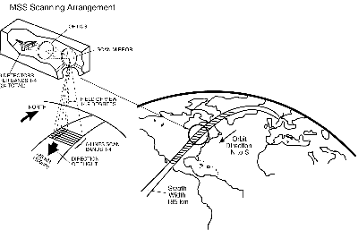
Data Integration - linking different information through GIS MSS Scanning Arrangement