scanning |
Scanning
How to confront these extensions without neither contours nor limits? It is the problem of apprehending dimensions that escape completely to the individual experience. The notion of scanning was introduced by Carl Andre and Robert Morris as a mode to see in large-scale, emphasizing horizontality and distance. It is a type of observation that, instead of fixing in an object, operates covering horizontally an area. It works by scanning. In the distance it is imposed for each object, the horizon being valid in such a way how much the center.
Scanning is also an observation mode specific to radar and satellites. Systems of seeing engendered by advanced observation equipment. For large extensions, transcontinental, planetary scales.
Scanning is a device that does not correspond anymore to the ocular device, to the organization of the space made by the eye. The peripheral, lateral, horizontal vision, instead of the focus centered in an object, turns possible to confront the large scale.
Once these forms are so large, practically incompressible from the ground, they suppose an overview. Intrinsic contradiction to the large scale: the observer vision is estimated panoptic, capable to comprehend the abstract forms delineated there, but at the same time the patterns engendered only appear in fragments. So the essential concept of mapping: fusing of the real and the abstract. The map introduces the idea of a ' vision ' that encompasses what no point of view can comprehend. The mapping comes to be the first image of a landscape that cannot be apprehended directly by the eye. A mode of not-ocular perception.
The relation with these scales, that vision cannot reach, demands another approach. Morris suggests an observer sensing instead of seeing these large configurations. For him, the large spaces are related with a vision mode that differs from readings in gestaltics forms, including terms. This mode of perception looks for parameters in which the totality appears as resulted of a set of information, where heterogeneity and indetermination are constituent, instead of being immediately perceived as an image. An approach that already announces the more contemporary forms of understanding the mapping processes, based in the intensive and critical scanning of multiple information.
References
R. Morris, Continuous Project Altered Daily,
MIT, Cambridge, 1995.
Images
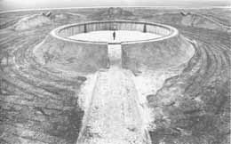
R. Moris, Observatory, Holanda, 1977
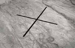
D. Oppenheim, Relocated Burial Grond, 1978
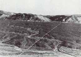
R. Long, Walking a Line in Peru, 1972